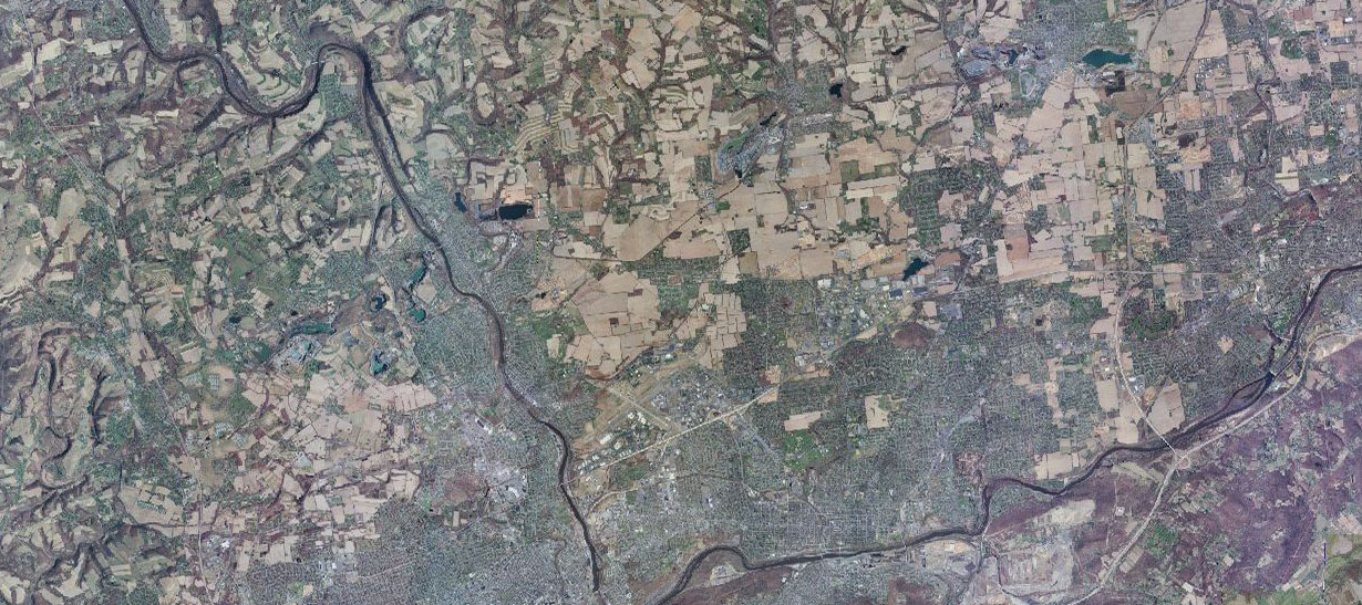
The Pennsylvania landscape is a diverse and rich environment for those interested in remotely sensed data. From its broad vistas of the ridge and valley province, to its rich farmlands and massive state park system, to its densely populated urban areas, the Commonwealth provides a unique setting for understanding the importance of satellite derived data and its role in decision-making and education.
PaView is an AmericaView partner. For more information on AmericaView, click the Learn More button.
In the state of Pennsylvania, Allegheny County has the second largest population after Philadelphia. For some time, the county’s population has witnessed a steady and continuous decline. Not until the last 10 years that its population started to show some increase. According to the latest Census data of 2020, Allegheny County witnessed a 2.2% increase from 2010. Moon Township was one of the largest communities that had a significant population increase during this period (12.6%). On the other hand, Marshall Township, located in the north and shares a border with Butler county’s Cranberry township, has almost doubled its population (45.8%) during the same period. In this study, we take a deeper look at the spatial changes that occurred during the last 10 years. Assessment of vegetation cover in general and tree cover in specific was conducted. However, despite the significant population growth of those areas, the results show a general increase in vegetation cover in both townships. The methods used in the current study adopted modified vegetation indices that were calculated from high resolution multispectral aerial images, as well as the extraction of tree cover from LiDAR point cloud data. The results show potentials and challenges of those methods. Finally, it is suggested that more structured accuracy assessment to be conducted on the presented results, and method refinements to include other hybrid techniques are to be investigated.
Learn MoreTransport of sediment through small streams is linked to agricultural soil loss, erosion and deposition in stream channels, and ultimately to the sediment that is choking parts of the Chesapeake Bay. Earlier research at Bucknell developed GIS (Geographic Information Systems) tools to calculate, based on a high-resolution digital elevation model (DEM), a sediment transport capacity index, Tc for any point along a stream or concentrated flow path. It is defined as the product of the land area contributing runoff at a point and the slope of the channel at that point (Moore and Wilson, 1992). Earlier work showed a significant correlation between Tc at a point along a flow path and another variable dependent only on DEM data. That other variable is based on the difference between the land surface elevations measured by LIDAR in 2006 and in 2017 (Edif), where positive values indicate erosion and negative values indicate deposition. In a channel transporting large amounts of sediment, erosion and deposition likely occur repeatedly over storms, seasons, and years, with some parts of a reach showing deposition and others erosion. A strong case can be made that high variability in Edif within a reach corresponds to large flows of sediment in the reach, and high sediment flow should correspond to high Tc values. Specifically, the earlier work showed that the standard deviation of Edif, that is, std(Edif), is significantly and positively correlated with Tc. Figure 1 describes how the Edif layer can inform the evolution of the thalweg (the path of the deepest part of the channel).
Learn MoreImagery was acquired from multiple sources (Planet Lab and SPOT-6 1.5m pan-sharpened, orthorectified imagery) to piece together data of the City of Philadelphia before and after Hurricane Ida hit. One neighborhood in particular was used as a case study in this research which had reported significant impacts from flooding during Hurricane Ida as well as a previous tropical storm that occurred in 2020, Tropical Storm Isaias. Each image included RGB and Near- Infrared bands that allowed researchers to utilize the Normalized Difference Water Index (NDWI), a calculation which enhances open water features while reducing the reflectance of soil and vegetation features (see equation below). This reveals a range of values from -1 to 1 in which positive values reveal water features or saturated areas, while anything less than or equal to 0 are estimated to be vegetation or soil .
Learn More
The statewide orthoimagery data from PEMA is now available va PASDA. It includes a statewide cached map service, and individual tiles and county mosaics.
Project specifications are based on the U.S. Geological Survey National Geospatial Program Base Ortho Specification, Version 1.0. The data were developed based on a horizontal projection/datum of NAD83 (2011) State Plane Pennsylvania North FIPS 3701, US Survey Feet.
PASDA is now hosting multiple recent QL2 LiDAR data sets. The lidar has been gathered via funded projects from FEMA, NRCS, and USGS and state partners PA DEP, PennDOT, PA DCNR, PEMA, Turnpike Commission, and the Susquehanna River Basin Commission. The data was created between 2014 and 2018 and 2019-2020. Information about data collection progress and coverage can be found on the PA Elevation Working Group site All data is available via PASDA.
Sed egestas, ante et vulputate volutpat, eros pede semper est, vitae luctus metus libero eu augue. Morbi purus libero, faucibus adipiscing, commodo quis Gravida id, est. Sed lectus. Praesent elementum hendrerit tortor. Sed semper lorem at felis lorem ipsum dolor.
Sed egestas, ante et vulputate volutpat, eros pede semper est, vitae luctus metus libero eu augue. Morbi purus libero, faucibus adipiscing, commodo quis Gravida id, est. Sed lectus. Praesent elementum hendrerit tortor. Sed semper lorem at felis lorem ipsum dolor.
Sed egestas, ante et vulputate volutpat, eros pede semper est, vitae luctus metus libero eu augue. Morbi purus libero, faucibus adipiscing, commodo quis Gravida id, est. Sed lectus. Praesent elementum hendrerit tortor. Sed semper lorem at felis lorem ipsum dolor.
Sed egestas, ante et vulputate volutpat, eros pede semper est, vitae luctus metus libero eu augue. Morbi purus libero, faucibus adipiscing, commodo quis Gravida id, est. Sed lectus. Praesent elementum hendrerit tortor. Sed semper lorem at felis lorem ipsum dolor.